If you’ve ever had a drink of orange juice, chances are it crossed these tracks. The Tropicana train crosses this river.
Daily Image
Tracks crossing the Manatee River to the Tropicana Plant
I live within earshot, so I hear the horn in the morning and at night. It’s part of the soundscape of my hometown. The idea of a town having a soundscape is new to me, but if I were blind, I’d know it very well.
If you look closely at the patterns on the water, you can see the direction of flow. The eddies caused by the supports are on the downstream side. But as this river flows into the ocean, the direction changes with the tide. As the tide changes, the flow is non-existent. But that’s another shot for another day.
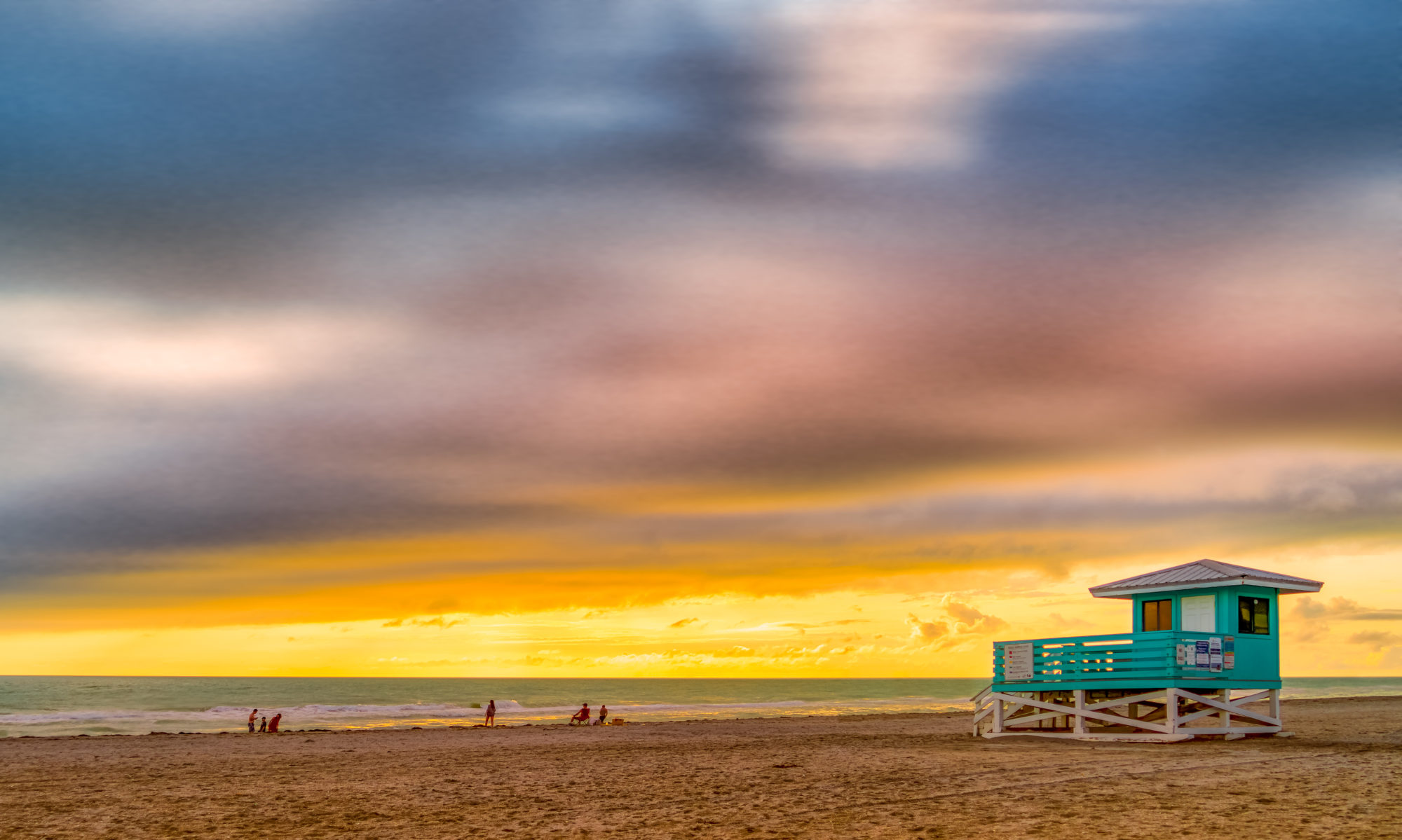
Now tell me, do we get amazing sunsets in Florida or what? I took this crazy panorama of my hometown of Palmetto last Friday. In fact, my drone took this photo. I sat out front with a refreshing beverage in a lawn chair and sent my robot drone up to take the picture. Okay, so I’m exaggerating a little, I had to pilot it, compose the shot, and press the shutter button, but with a little more AI, maybe it could do that too.
Daily Image
A multi-image panorama of Palmetto Florida one evening in August of 2018
Typically, when I take photos, I get my gear, put it in the car, and drive somewhere. Then I get the gear out of the car, walk, compose, and click. Then, I walk some more and do it again, over and over. After all that, I end up with one or two good shots, and then I’m tired. But this time I decided to sit back in a chair and send the drone up. No driving, no packing, no walking.
This whole experience got me thinking that these drones are very close to becoming robots. Fast forward ten years and I’ll be sitting in my living room with a VR headset talking to Siri. I’ll ask her to send up the drone, fly somewhere special, look around, and take a photo as if I was there myself. I won’t leave the comfort of my home. Does that sound absurd? I wonder if the idea is not too far off the mark.
Here I am on the Loop Road in Big Cypress Nation Preserve. I was in the middle of hundreds of square miles of wilderness as far as the eye could see. However, the land is so flat you can’t see distances at all. So I stopped along the side of the road and sent the drone up for a look.
Daily Image
The landscape of Big Cypress National Preserve along the Loop Road
I suppose this is a selfie of sorts. I’m down there behind my car trying to see the view on my iPhone screen. But, it was so sunny that I was having difficulty viewing it. Nevertheless, I took a few still shots including this.
On this day, it was just a quick up and down flight for a few shots because I just wanted to get a sense of how the landscape looked. It’s also because I’m a nervous drone pilot and I worry about losing it in unfamiliar places. The drone is so small that you quickly lose sight of it. However, Mavic Pro is supposed to fly back if something goes wrong, in other words, it’s dummy-proof. Even so, if it crashed here, there is no going to look for it. With alligators and snakes at every turn, it would take a far braver man than me to go and look for it.
This is a picture I took this last summer of the street I live on. Now it’s cooler and as I look this I think of those warmer months. But to be perfectly honest, summer is hot as hell and the cooler weather is a nice change.
Daily Image
This street divides the urban from the wild
On the left is a row of townhouses where I live. On the right is open land that is a little wild and not yet developed. The street in the middle divides the urban from the wild. I look out the upper window and see nature just doing its thing.
Out there are all manner of wild animals. I’ve seen eagles, fox, coyote, and alligator to name a few. They all live literally within a stone’s throw; right over the fence. Sometimes it’s hard to believe that wildlife can live so close to our urban setting. If your someone like me that loves animals, I tend to worry about them and wonder how long they can hold out. My fingers are crossed.
I took this sunrise over the Manatee River with a drone one morning. For years I wanted to take a helicopter so I could get a photo with this perspective, but now I just use the DJI. It’s a lot cheaper and I don’t have to hang out the door to get a shot.
Daily Image
Sunrise over the Manatee River as viewed from a small DJI MavicPro drone camera
The town of Bradenton is on the right and my home town of Palmetto is on the left. The traffic flows into Bradenton over the second bridge in the morning and the other way at night. The first bridge is the rail bridge to the Tropicana plant. In the old days the trains carried people, now it only carries oranges to the plant and juice in the other direction. If you buy a container of orange juice, chances are it crossed that bridge.
I was standing on a pier just off camera to the right. The drone was so high and far away from me I couldn’t actually see it with my eyes. But I could tell where it was through the live feed it was sending back. I always get a little nervous when it’s so far away, but nothing happened and I got the image I’ve been waiting so long for.
Here is an overhead shot of Coquina Beach I took last summer. The camera is pointing west but the beach is diagonal. It’s something I never noticed from the ground. In this case I was standing about a mile up the beach recording video of the waves and stopped to shoot this still. I still think it’s strange that I can be taking photos remotely.
Daily Image
Overhead shot of Coquina Beach on Anna Maria Island, Florida
When I’m flying the drone, I don’t like to get too close to people. If I was going to the beach to relax I would not want to be irritated with the sound of a quadcopter buzzing overhead. When they first came out it was a novelty, but now with so many people flying them I think a little etiquette is in order.
In this case I’m flying high enough above the beach that the sound of the drone is not audible. And, the drone is so small that most people would never notice. This way I can fly up and down the shore line looking for compositions without disturbing anyone.
One other thing I’ve tried is flying a parallel path a hundred yards out over the water. With the overhead perspective I can see marine wildlife such as dolphins, manatees and sharks. That’s not unusual for this area, just part of the normal scenery from a drone.
This is a panorama of Anna Maria Island taken with a drone the other day. To get this I took seventeen images and re-combined them in post-production. It’s not as difficult as it sounds but the results can be stunning. This is a perspective I’ve never seen; I come here all the time but like everyone else I see it from the ground.
Daily Image
Panorama of Anna Maria Island from the air
I like to think that I’m not afraid of heights, but when I fly the drone and look at the live view on my iPhone I get a little queasy. It’s a form of virtual reality, almost as if I’m in two places at once, simultaneously on the ground and in the air. From the air I look straight down and think to myself, it’s a long way down.
Phobias aside, the island is very low-key as compared to other places in Florida, it reminds me of Hawaii. The beaches are almost always filled, yet there are no flashy or tall buildings, just relaxed places to hang out and chill. I recall that in certain parts of Hawaii the building codes don’t allow for anything taller than a palm tree, I think it’s the same idea here.
The only way you’ll ever see this view for yourself is if you take a parasailing ride up and down the beach; or, if you happen to have a drone and can virtually fly with your feet still on the ground. In either case, it’s a long way down.